Sometimes, all it takes is one look at an old map to make you want to pack your bag and vanish for a while. The Bahamas are exactly that kind of place. Every island has a different shape, a different story, and above all—names that feel like something out of a pirate novel. You won’t find “Beach #3” on these maps, but you might stumble across Devil’s Bluff, Man of War Cay, or Hole-in-the-Wall.
And that’s what I find so magical about these historical maps—they bring the islands back to life. Back to when every little bay had a name, and every cay was important enough to be drawn by hand.
Abaco: Pine Forests, Windy Reefs & Pirate Vibes
Abaco isn’t just one island—it’s a whole chain of islets, cays, and shallow waters known as The Marls. On the map, the names jump out at you like chapters from a sea adventure: Treasure Cay, Green Turtle Cay, Pelican Harbour, or the mysterious Joe Downer Cay. (Seriously, what happened there?)
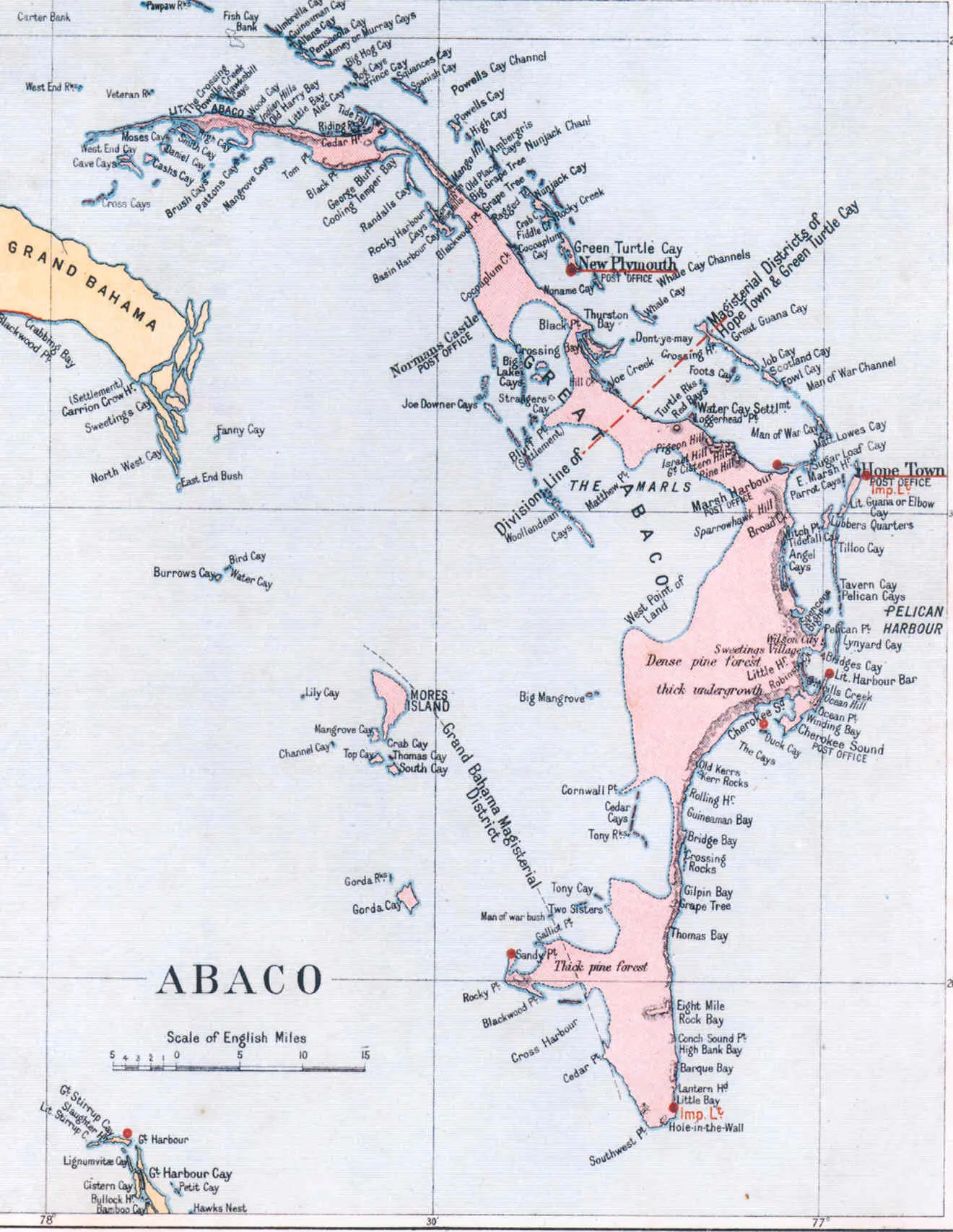
What surprised me most? Abaco has pine forests. Real ones. The maps even mark “dense pine forests” and “thick undergrowth.” That’s not what most people imagine when they think “Caribbean.”
But that’s the beauty of it—it’s unexpected, rugged, and full of wind-swept corners that make you want to sail without GPS.
Andros: The Wild, the Wet, and the Wonderfully Named
Andros is the biggest island in The Bahamas, and honestly? It feels like its own world. It’s divided into three districts, each with post offices, creeks, blue holes, and unforgettable names like Love Hill, Rat Cay, Hard Bargain, Fresh Creek, or Flamingo Hole.

It’s home to some of the most beautiful blue holes in the world—deep, crystal-clear sinkholes that divers dream of. But what I love most are the local legends and the way places are named after people, animals, or pure poetic chaos.
Like Umbrella Cay—misspelled as “Unbrella” on the map. Or maybe that’s part of its charm.
Berry Islands: Tiny, Quirky, and Absolutely Enchanting
If you love names that sound like they came out of an old explorer’s logbook, the Berry Islands are a dream. Dotted with cays like Devil’s Cay, Mamma Rhoda Rock, Cockroach Cay, Frazer’s Hog Cay, or Ambergris Cay, these islands look like pearls scattered across the ocean.
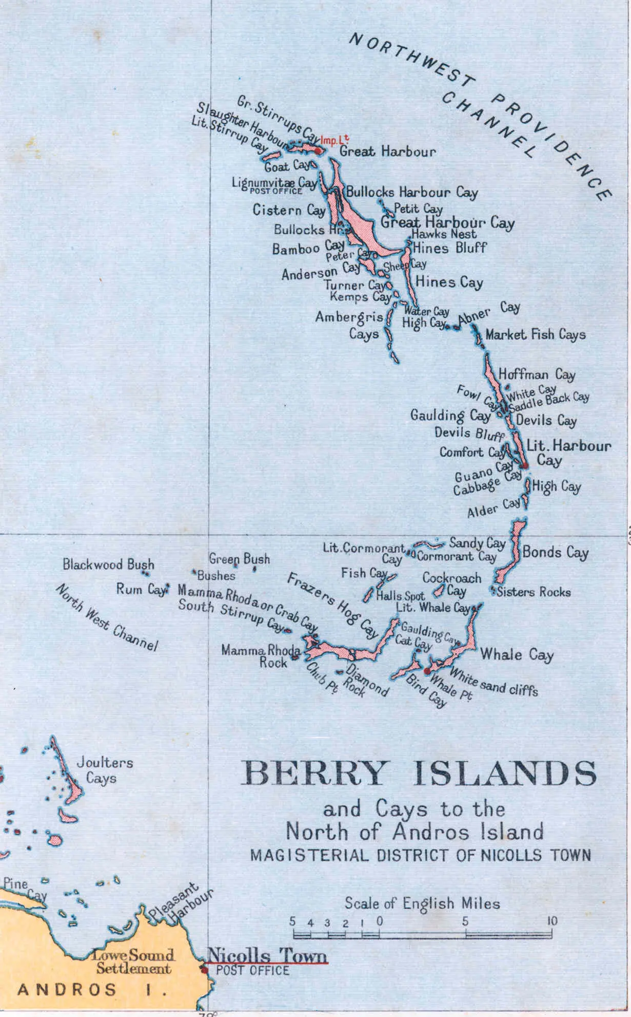
There’s a place called Whale Cay, another called Slaughter Harbour, and one named Gaulding Cay. The vibe? Isolated but full of secrets.
What really got me is that even the smallest islands were part of a postal route—one that ran from Nicolls Town in Andros. Imagine boats navigating these tiny waters, delivering letters from cay to cay. That alone feels like a story worth telling.
Bimini: Close to Florida, Closer to Legends

Bimini is the westernmost point of The Bahamas—so close to Florida you can almost wave to it. The maps split it into North Bimini and South Bimini, and even though that sounds basic, the place names are anything but: Victoria Ridge, Nixes Harbour, Alice Town, and even notes like “tops of trees about 40 ft. high.” Yes, seriously—these old maps cared about tree height.
But the true charm of Bimini lies in its legends. Some believe the Lost City of Atlantis is hidden beneath the waves here, along what’s known as the Bimini Road. Local boat captains are more than happy to tell you their version over a cold drink.
Eleuthera: Long, Thin, and Full of Character

Eleuthera stretches like a ribbon across the map—a narrow strip of land that somehow holds a lot of soul. It’s one of the older islands in terms of settlement, once home to English Puritans who arrived in the 1600s.
Names like Governor’s Harbour, Dunmore Town, Hatchet Bay, Savannah Sound, or James Cistern all pop out from the map like clues to a story. There’s even a place named New Portsmouth or Rock Sound, a reminder that this island once saw settlers dream up new towns from scratch.
Eleuthera is the kind of place where maps don’t just show geography—they preserve history.
A Quick Travel Tip You’ll Thank Me For
If you plan to explore these islands, whether you’re hopping between cays or working remotely with your feet in the sand, don’t forget to use a VPN. It’s not just about unlocking your favorite streaming services (though that’s always a bonus). It’s also about security.
Public Wi-Fi on boats, in small island hotels, or beach cafés isn’t always safe. I keep a VPN on at all times—especially when checking emails, making payments, or booking the next ferry ride online. It gives me peace of mind.
👉 I recommend:
- NordVPN – fast, reliable, and great for streaming and banking.
- Surfshark – affordable and allows unlimited devices (perfect for couples or families).
- ExpressVPN – user-friendly, especially if you’re new to VPNs.
In short, a VPN isn’t just for techies anymore—it’s for anyone who wants their trip to stay carefree.
| Best VPN | Offer + Discount | URL |
|---|---|---|
| NordVPN | 77% off + 3 months free | Try NordVPN |
| ExpressVPN | 61% off + 6 months free | Try ExpressVPN |
| SurfShark | 87% off + 2 months free | Try SurfShark |
Exuma: A Necklace of Islands with Stories in Every Cay
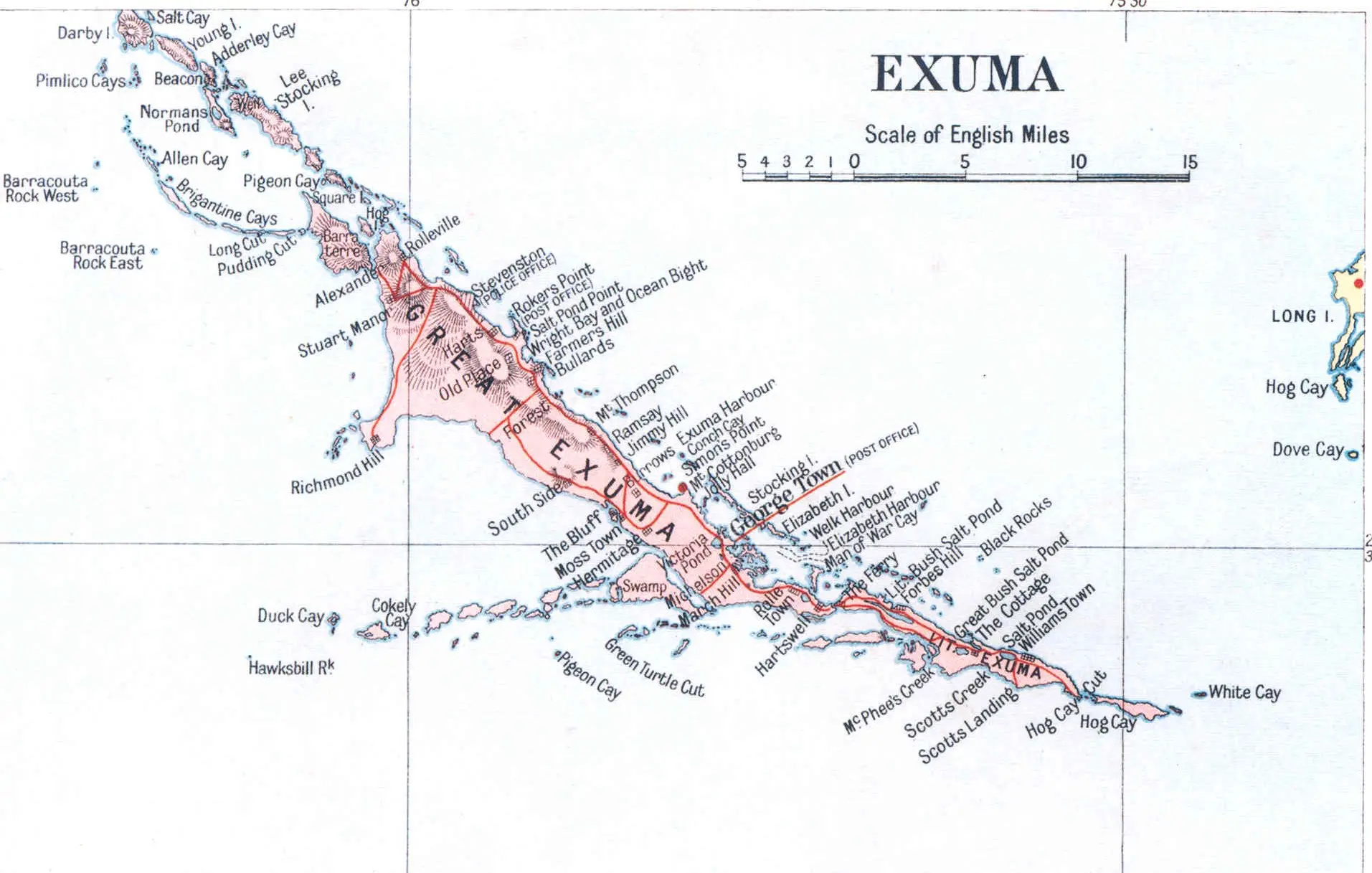
Looking at the old map of Exuma is like seeing paradise drawn by hand. It’s not just one island—it’s a chain of hundreds of little cays and islets stretching like a broken necklace across the sea. And each one has a name worth googling: Allen Cay, Stocking Island, Pigeon Cay, Elizabeth Island, Great Bush Salt Pond…
The main town, George Town, sits quietly in a protected bay. On the southern tip, you’ll find places like Hawksbill Rock, Scotts Landing, and White Cay, and it’s easy to imagine early sailors navigating this maze by instinct, stars, and handwritten maps.
Long Island & Rum Cay: Remote, Wild, and a Little Forgotten
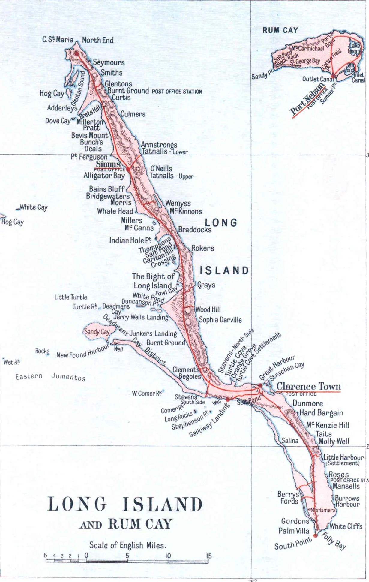
Long Island lives up to its name—long, narrow, and dotted with poetic place names that make you want to grab a journal. There’s Clarence Town, Deadman’s Cay, The Bight, and Whale Head. Every name sounds like it belongs in an old sailor’s story.
This island feels rugged, raw, and unbothered by modern tourism. The southern points have coves so untouched, it’s like stepping into a painting.
Right next door is Rum Cay—smaller, quieter, and just as mystical. It’s named after rum, obviously, but its map is filled with places like Salt Pond, St. George Bay, Black Rock, and Port Nelson. These aren’t just dots on a page; they’re whispers of a time when maps were hand-drawn and islands were discovered one by one.
New Providence & Paradise Island: Then and Now
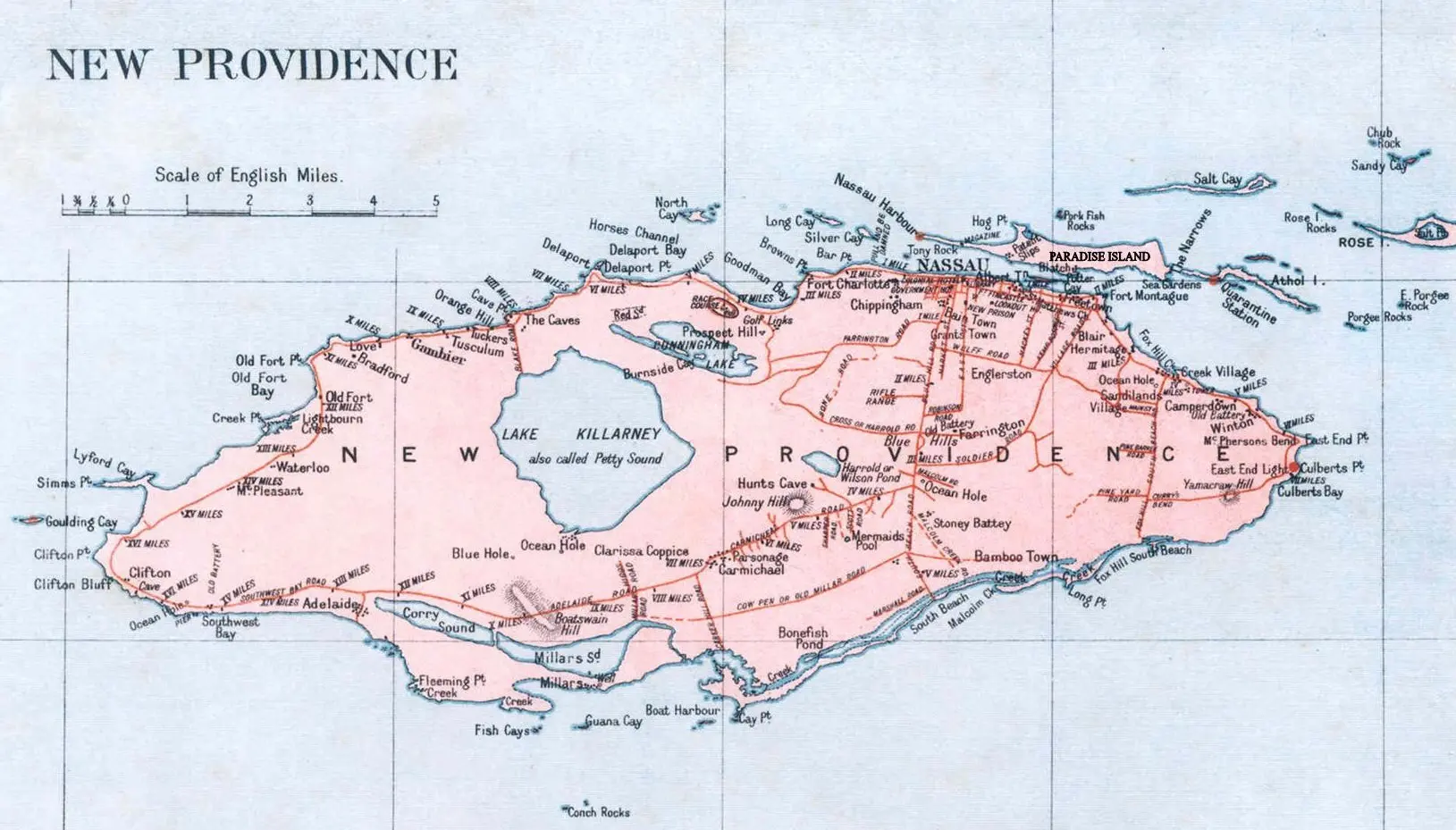
New Providence is home to Nassau, the capital—and if you’re only familiar with the Bahamas through cruise ship brochures, this is probably what you imagine. But even here, the old map tells a deeper story.
You’ll find Lake Killarney, Fox Hill, East End, Chippingham, Winton, and Fort Charlotte, each marked with care and precision. Even the small inland lakes are named, and there’s a rhythm to the map that you won’t get from GPS.
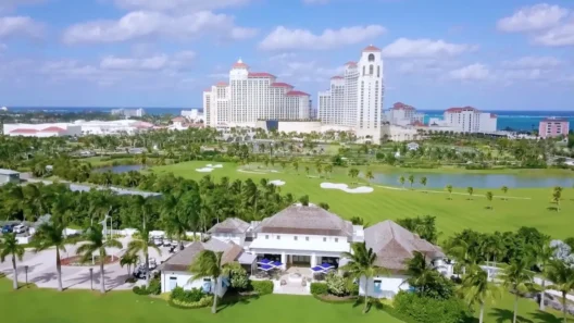
Right across the water sits Paradise Island, now known for its massive hotels, casino lights, and private beaches. But back then? Just a bridge and a quiet dot on the paper.
It’s almost poetic—how something so humble could grow into such a bold destination.
Why These Old Maps Still Matter
What I love most about these maps isn’t just how they look—but what they preserve. Before tourism, before developers, before drones and Instagram, someone carefully charted every cay, rock, and mangrove. They noted post offices, forest density, reef hazards, and water depths. They drew in the wind directions, the tree heights, and even the jagged cliffs.
These weren’t just navigational tools. They were art. Memory. Identity.
And looking at them today, you start to wonder how many places have changed names—or simply disappeared from our collective memory.
Final Thoughts (and a Few Travel Nerd Tips)
- Print the maps. Seriously. Take one with you. Locals love them and might even tell you stories you’d never find online.
- Visit the less-known islands. Berry Islands, Rum Cay, Long Island—they’re peaceful, unspoiled, and still hold that mysterious charm.
- Ask about names. Why is it called Buzzards Bay? Who was Joe Downer? These names often lead to the best conversations.
- Don’t rely solely on tourist guides. The old maps will show you parts of the Bahamas you’d otherwise miss.
- And yes—always use a VPN, whether you’re booking a room, streaming a show, or checking your bank account from a hammock.
Experience the Adventure in the Bahamas
One Last Island I’d Love to Visit?
Honestly? Wemyss Bight, down in Eleuthera. The name alone caught my eye. But truly, I could spend weeks just pointing at places on the map and seeing what’s there today. There’s something thrilling about chasing old names across modern sand.
Because on the Bahamas, even the smallest cay has a story. And old maps? They just might be the best way to find it.
Your Questions Answered: Old Maps, Islands & Travel Tips
What makes vintage maps of the Bahamas so unique?
Vintage maps capture the Bahamas before mass tourism, showcasing forgotten cays, handwritten place names, postal routes, tree heights, and even wind directions—making them both historical documents and works of art.
Can I still visit the places shown on old Bahamas maps?
Yes, many of the locations still exist, though some may have changed names or become less accessible. Islands like Eleuthera, Abaco, and Long Island still preserve their old charm and are perfect for map-based exploring.
Why should I use a VPN when traveling in the Bahamas?
Using a VPN ensures your data stays safe on public Wi-Fi (like in hotels, airports, or cafés). It also helps you access content from back home and avoid regional restrictions on streaming or banking services.
Which VPNs are best for travel in the Bahamas?
Top recommended VPNs for security, streaming, and unlimited devices include NordVPN, Surfshark, and ExpressVPN. They’re fast, reliable, and easy to use while island-hopping.

